|
|
|
|
October 26, 2010
San Diego County and CAL FIRE Team with UC San Diego Researchers on Early Fire Detection System Note: This is a reprint of an article by Doug Ramsey (Calit2). The original can be found at http://calit2.net/newsroom/release.php?id=1753. San Diego, Oct. 26, 2010 -- Researchers from the University of California, San Diego have installed 16 cameras on Mount Woodson and Red Mountain to provide 360-degree coverage extending for miles from those peaks to make it easier and faster to detect or monitor wildfires in unincorporated areas of San Diego County. The FireSight project extends the UCSD-based High Performance Wireless Research and Education Network (HPWREN) in areas where fire officials saw the greatest need.
"Employing modern technology for early fire detection is a key component of the region's firefighting capabilities," said San Diego County Supervisor Ron Roberts, who championed funding for FireSight. "The County recognizes the importance of working with university researchers to come up with better solutions for the future, but we also saw the critical and immediate need for more cameras and weather stations now. By augmenting HPWREN's current network, our county's first responders gain access to better and faster detection capabilities." In mid-September the Board of Supervisors appropriated roughly $36,000 in funding from the Neighborhood Reinvestment Budget, and the first additional sets of megapixel network cameras are now operational - just in time for the heart of the fire season. At a news conference Tuesday at the California Institute for Telecommunications and Information Technology (Calit2), UC San Diego researchers, Supervisor Roberts, and Howard Windsor, chief of the California Department of Forestry and Fire Protection (CAL FIRE) briefed reporters on how the early fire detection and remote monitoring system enhance the region's ability to detect and fight fires. Each of the cameras deployed on Mt. Woodson (2,800 feet) and Red Mountain (1,600 feet) feeds an image to HPWREN's public website, and each is refreshed approximately every two minutes with an updated image.
"The HPWREN wireless network is already being used by emergency agencies, including CAL FIRE, to track the progress of fires with our meteorological stations and over 20 mountain-top cameras before the latest upgrade," said HPWREN director Hans-Werner Braun, a research scientist at UCSD's San Diego Supercomputer Center (SDSC). "We have also provided critical wireless connectivity to various Incident Command Posts and other firefighting assets. But the funding from the San Diego County has allowed us to plug major holes in the infrastructure by ensuring that cameras in these two locations will give fire officials and first responders a 360-degree view - something they have not had until now." According to CAL FIRE's Windsor, the eight cameras deployed on Mt. Woodson and a similar number on Red Mountain (near Fallbrook) will give his team greater visibility in a large, rural area where the terrain and distances make it difficult to maintain firefighters on the ground all the time.
"Wildfires are a constant threat in these areas, so every bit of information we can get in real time, as it's happening, will allow us to react more quickly and accurately, because we'll be able to see the situation with our own eyes," said Windsor. "The FireSight project is adding a substantial number of cameras on the HPWREN network. The cameras are in regular use by the CAL FIRE Emergency Command Center, and our situational awareness goal is to have quick insight into the location and scope of a fire anywhere in San Diego County." In addition to the cameras, FireSight will add more weather instruments to augment the existing HPWREN "fire conditions" pager alert system. The sensors measure wind speed and direction, precipitation, barometric pressure, temperatures and relative humidity. The FireSight system grew out of discussions between Calit2 and San Diego County about ways to use technology to combat wildfires. The cameras and meteorological stations are a step in the right direction, and Calit2 director Larry Smarr says that the partnership itself bodes well for future innovations to improve disaster response.
"FireSight represents an important next step in the growing strategic collaboration among San Diego County, CAL FIRE and UC San Diego," said Smarr. "The camera installation is a visible symbol of this institutional shift. Thanks to the support of the County Board of Supervisors, we have extended the wireless camera coverage on the HPWREN infrastructure to provide a greater chance of early warning, so we can stop small fires before they can develop into the large-scale fires San Diego experienced in 2003 and 2007." While the FireSight project targets fire protection, UC San Diego researchers believe that the partnership with the County and California state agencies will eventually go beyond fire detection, to formalize other collaborative activities with the university. Supervisor Roberts, who represents the Fourth District, also recognizes that FireSight is just the beginning of a long collaboration.
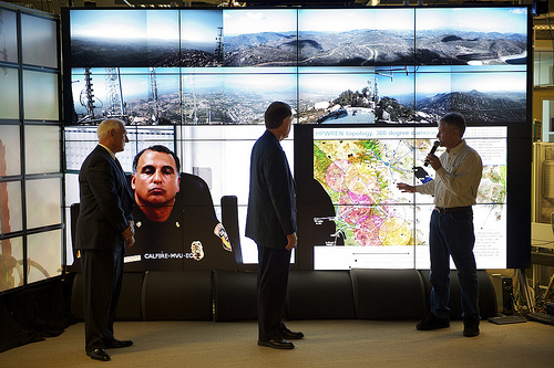
"Our role has been to bring the fire experts and technology experts together," said Roberts. "Their overlapping skill-sets create amazing opportunities for synergistic collaborations, and everyone has a single goal in mind: to make San Diego County a better and safer place to live for all of its residents." The FireSight briefing for the media took place at Calit2 on the UCSD campus. Using the highest-resolution display system in the world (over 315 million pixels), the HIPerVerse allowed reporters to see feeds simultaneously from all 16 cameras deployed as part of FireSight. The technology also allowed CAL FIRE unit chief Windsor to participate remotely in the briefing via videoconference from the Emergency Command Center at Monte Vista (El Cajon). HPWREN's Braun also showed a compilation of network camera feeds from the 2007 Harris fire. Note to Editors: 20-second video clip of deployment of cameras on Mt. Woodson and Red Mountain can be downloaded in multiple formats from here. Separately, a compilation of camera feeds from other HPWREN installations chart the progress of the 2007 Harris Fire; those time-lapse videos can be downloaded here. Related Links |