|
|
April 18, 2006
HPWREN Enables Real time Monitoring of Coastal-Interior Microclimates
Using HPWREN and the San Diego State University Biological Field Station Programs' Santa Margarita Ecological Reserve (SMER) "Intra-SMER" wireless network, real time weather data is being collected from an array of weather stations that cover several different microclimates in SMER. The data from the array provides an ongoing update of weather conditions across SMER's complex terrain along with a perspective from a growing historical period, as illustrated in the recent "snapshot" in Figure 1.
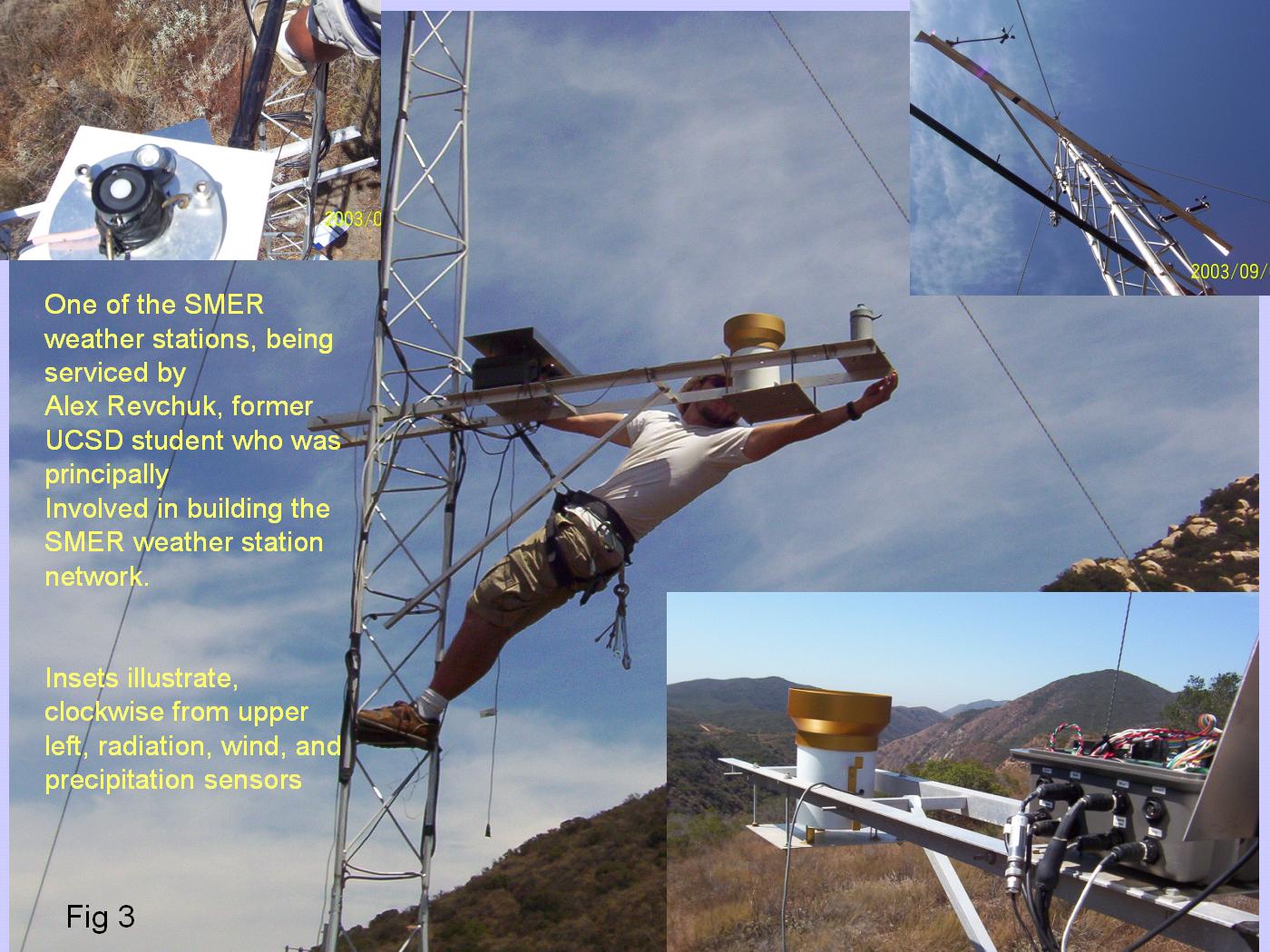
The concept for the array was seeded in Fall 2001, when several investigators funded by the National Science Foundation under the ROADNet and HPWREN projects convened to discuss avenues to make use of emerging high speed communications systems to support environmental monitoring and other problems in the greater San Diego County area. Amongst other highlights of this meeting, a feature that emerged was that HPWREN had established connections to the Santa Margarita Ecological Reserve (SMER), which had subsequently built a local wireless network to establish wireless Internet connectivity within the SMER boundaries. This enabling infrastructure, together with SMER's secure physical setting and expert staff, encouraged us to think about how we could monitor weather and other environmental characteristics at SMER. The coast-to-interior transition zone that SMER occupies is typical of a scientifically very interesting environment as well as the home of much of California's human population. In Summer 2002, armed with a new data logger developed at the Scripps Integrative Oceanography Division (IOD) at Scripps Institution of Oceanography (SIO), we began installing in SMER a uniquely dense array of meteorological stations. Installation was carried out mostly by Alex Revchuk, at the time an SIO undergraduate student, with help from Mark VanScoy of SMER, Pablo Bryant of the SDSU Field Programs, and Spencer Kawamoto and Douglas Alden of SIO IOD.
Transition zones such as the Santa Margarita watershed have complex topography and relatively high gradients in temperature, humidity, and other elements. To adequately measure this structure requires an array of instruments that is considerably denser than existing meteorological networks, in order to distinguish spatial detail and understand temporal variability. Presently, an array of 22 meteorological stations have been installed (Figures 2 and 3) across the rugged terrain of the SMER domain, spanning a patch from low elevations, as low as approximately 860 feet (265 meters), in the southwest portion of the domain, to high elevations, approximately 2200 feet (670 meters), in the northeast portion of SMER. To reference the weather at the SMER stations with that along the Pacific margin, the weather stations and the SMER wireless facility was extended about 15 miles westward to a coastal weather station along the shore in Camp Pendleton, as shown in the inset map in Figure 2.
Along with the technological advantage provided by SMER and HPWREN, a key component of this monitoring program was to build on existing efforts in the SIO IOD to develop a low power, low cost, small format logger/transmitter (Figure 4). The result was the DL1-Met which has been developed by Douglas Alden, with help from Spencer Kawamoto, for remote meteorological and hydrological monitoring applications. The DL1-Met is an embedded system built around a Texas Instruments MSP430F149 mixed signal microcontroller. This microcontroller was selected because of its low power requirements, integrated 12-bit A/D converter, and multiple timer input channels. A diverse suite of environmental sensors connects to the logger, which is housed in a waterproof heavy duty plastic case and mounted to each 10 meter weather tower in SMER. These sensors measure temperature, humidity, winds, and solar radiation, sampled each second and averaged over the minute for storage on the logger. Maximum gusts for winds are stored along with the average wind values. Barometric pressure is measured once per minute. Precipitation is stored as a running total. Data are continuously logged, stored internally on a MultiMediaCard (MMC) for storage. An antenna cable connected to the telemetry unit runs from the enclosure to a 3dB omni-directional antenna at the top of the tower. Via 900MHz radio, a subset of 5 minute samples is transmitted to the SMER wireless network, which connects to the Internet via HPWREN. Under the one minute sampling rate operating on the present suite of 15 variables, a 32 MB card allows the logger to record almost two years of data. A key feature of this system is its low power draw. Quiescent power consumption of the full system is on the order of 7.5 mW with peak power consumption jumping to ~500 mW when the radio is operational. An alkaline D cell battery pack is used to power the logger. The battery pack is constructed of 12 cells: two parallel banks of six cells connected in series. Battery life is projected at one year given 75% efficiencies of the batteries and power supplies. Alternate electrical sources such as solar or AC can also be used to power the logger to extend the time it can be deployed. Lessons learned during this last 3-4 years and the need for additional sensors and other capacity have led to an upgrade of the DL1-Met to a soon-to-be-field tested new model, the DL4-Met. The DL4-Met will use a modular controller architecture to adapt to a growing suite of additional sensors and provide higher storage capacity. At SIO, under the direction of Alden, Kawamoto and Mary Tyree and Larry Riddle of the Climate Research Division, the data are displayed and archived in two forms. These consist of the transmitted subset, which is updated in real time, and the full sample from the MMC logger archive, which is updated occasionally as the MMC's are swapped out.
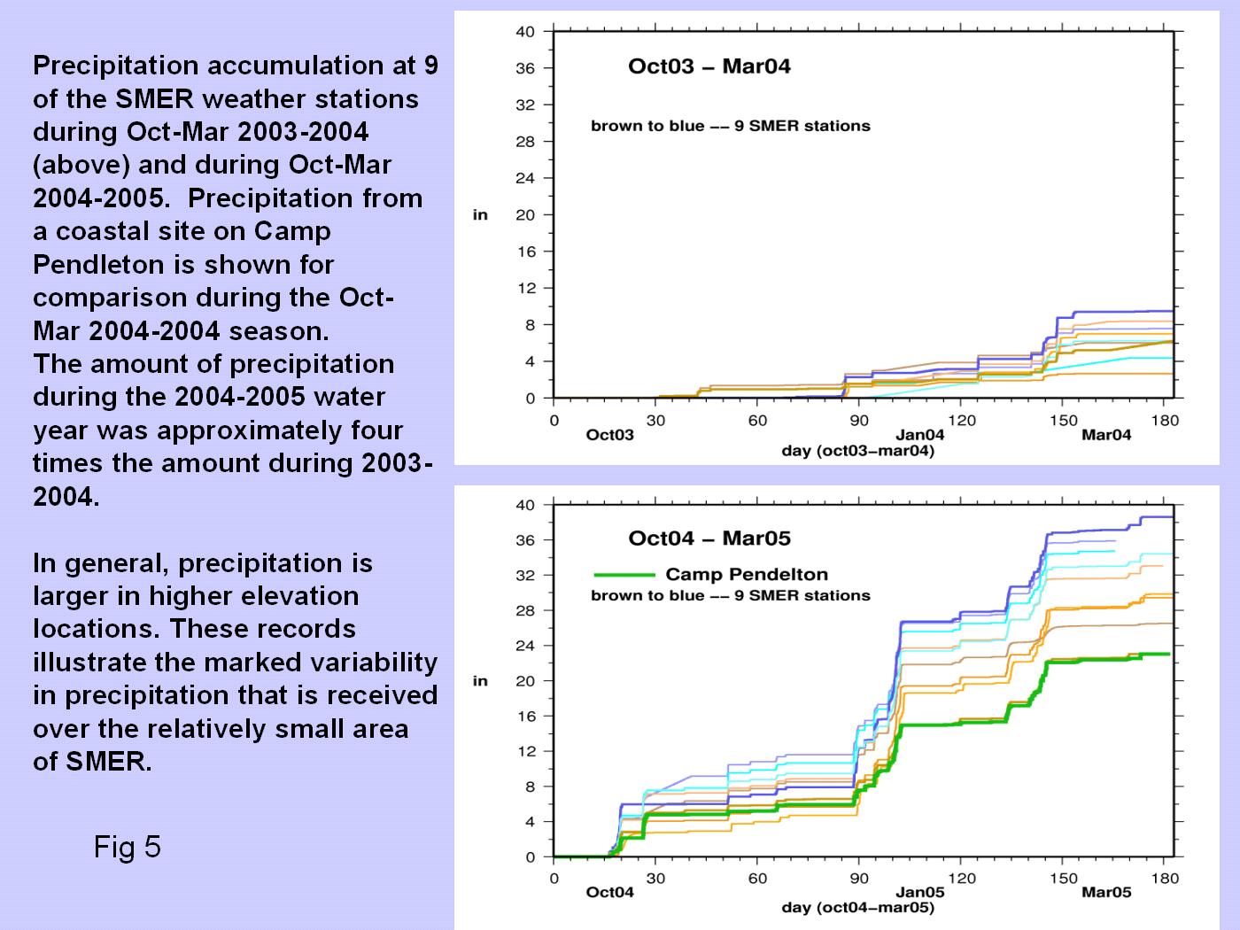
One defining characteristic of ecosystems in SMER and the Southern California transitional environment is the high degree of variability in the amount of moisture that is available. It was our fortune that as the SMER meteorological array was being installed, the area climate bounced between the extremely dry and extremely wet water years of 2003-2004 and 2004-2005, as illustrated in Figure 5. This disparity was recorded by all of the stations that were functioning in SMER during the two years. On top of the large interannual differences, the accumulated precipitation reveals the degree of variability that exists across the SMER landscape, as shown by the accumulations in Figure 5. The accumulated precipitation amongst the SMER stations has varied by a factor of two in 2003-2004 and by a factor of 1.5 in 2004-2005. The episodic nature of precipitation and associated atmospheric conditions is demonstrated by recent rainfall events since late February in Figure 1. Also included with the precipitation records collected from the SMER network in Figure 5 is a coastal precipitation record from Camp Pendleton, which demonstrates that precipitation can increase markedly from coast to the inland regime. Precipitation amounts during November through March 2005 ranged from approximately 23 inches at the coastal site in Camp Pendleton to 38 inches at the wettest station at SMER. It is important to determine if these observations are reflecting the climate and not spurious instrumental effects, so we are assessing the accuracy of precipitation rain gages at particular locations using redundant rain gages. Results, illustrated from the TCS8 station in Figure 1, indicate that side-by-side rain gages measure very similar precipitation events and totals. The replication of accumulated precipitation from these redundant gages suggests that differences in rain gage catch amounts are providing an accurate record of environmental variations rather than being driven by instrumental idiosyncrasies. The rain gage data also provides an important record of rainfall intensity. For example, when rainfall was recorded during the recent February to April wet spell, the five minute precipitation catch over this time period varied from 0.01 inches to as much as 0.12 inches. During the period since February 2006, the total precipitation at the TCS8 site was approximately 8 inches, which is a substantial portion of this water year's total precipitation.
HPWREN wireless connectivity is invaluable to view and investigate the SMER weather data in real time, and also to monitor station performance and data quality. The SMER weather data, along with that from our other experimental meteorological stations in the San Diego County and Sierra Nevada region, are available online at http://meteora.ucsd.edu/weather/observations/sio_other/crd_obs.html. The Scripps hydroclimate field program has been supported by NOAA's Office of Global Programs, NSF through the ROADNet project, and with ongoing support from the California Energy Commission PIER Program http://www.energy.ca.gov/pier via the California Climate Change Center http://meteora.ucsd.edu/cap. Dan Cayan
|