HPWREN Retrospective:
20 Years of HPWREN Collaborations with Firefighting and Other Public Safety Agencies
October 28, 2021
Summary
This article summarizes the somewhat unusual collaboration between a research project at the University of California San Diego and first responder agencies over the past approximately 20 years. Starting in 2000, the UCSD High Performance Wireless Research and Education Network (HPWREN) informally collaborated with wireless communications staff of firefighting and County agencies, specifically via the Emergency Command Center of the California Department of Forestry and Fire Protection, as well as the San Diego County Sheriff Department's Regional Communications System. While summarizing activities, milestones, and accomplishments the article includes many "for more details look here" links. As the collaboration progressed over time, in 2010 the County of San Diego contributed funding for additional cameras and other sensors to augment what HPWREN already had in place. Around that time HPWREN had a significant number of fire stations connected, which then led to San Diego Gas and Electric (SDG&E) supporting a substantial buildout of connectivity, cameras, and weather sensors for the San Diego County area, to encompass as many local, state, and federal fire stations as possible. The continuation of this buildout is by now directly supported via San Diego County, SDG&E, and fire agencies.
|
|
|
Highlighted activities of the overall HPWREN project can be found in an HPWREN overview video. An earlier summary about HPWREN Public Safety collaborations is available alongside much additional information at the HPWREN web site.
How things began....
The time of a federally provided general purpose national backbone network for the research and education communities had been coming to a close as of 1995. Its roots stemmed from early ARPA research on packet switching and its development of the TCP/IP protocol suite, which the NSF elected for its NSFNET program in the mid-eighties, at a time of a strong push towards GOSIP ISO protocols and support for X.25. The NSFNET, specifically with its Backbone network, had accomplished an objective of scaling the DoD Internet in the late 1980s to early 1990s towards broad and worldwide acceptance, laying the foundation for making significant strides into the public consciousness. A mere four years later, eons in Internet time, the technology had become viable enough that Frank Vernon, a geophysicist at the UCSD Scripps Institution of Oceanography approached Hans-Werner Braun at the UCSD San Diego Supercomputer Center with a request for help to transition his wireless earthquake sensor network to the Internet Protocol. Prior low power wireless systems were generally based on proprietary asynchronous serial protocols. This was needed so that the seismic stations in the ANZA seismic network could use the reliable state-of-the-art TCP/IP protocol suite. Little did they know that the two UCSD researchers would create the High Performance Wireless Research and Education Network (HPWREN) project which then morphed into a large-scale cyberinfrastructure in southern California. The wireless router network across mountain tops created extensions for diverse network requirements ranging from low volume but continuous traffic flow individual seismic sensors to the bursty high-volume traffic of the Palomar Observatory with researcher traffic that, for example, resulted in the demotion of Pluto as a planet.
While it was not part of the original plan, already in its early stages HPWREN extended into the public safety realm. For example, over time firefighting agencies from the local, state, and federal levels started to strongly rely on networked cameras for environmental observations that became part of the HPWREN project starting in the early 2000s. The public safety collaborations were not a result of HPWREN staff trying to convince them of new protocols and technologies, but rather an incidental result of HPWREN in 2000, with UCSD being a State of California entity, approaching those agencies for access to their tower infrastructure. HPWREN had asked them for their help in extending the wireless network in collaboration with researchers and educators. Both agencies were very helpful and cooperating as partners with the larger HPWREN project, allowing the project to be a guest at multiple of their sites. This resulted in a continuing informal exchange of ideas and HPWREN project updates, which helped keeping those agencies interested, informed, and involved.
For more than it's first ten years HPWREN was funded by the National Science Foundation, originally starting as a research project in August 2000 for "An Interdisciplinary Collaboration on Performance Aspects of a High Performance Wireless Research and Education Network" (ANI-0087344), followed in 2004 by a funding award for "Integration and Analysis of Reliable Networking for Remote Science, Education, and First Responders" (0426879), and an Accomplishments Based Renewal (OCI-0944131) in 2009. Braun was the Principal Investigator on those grants, with Co-Principal Investigator Vernon. Around 2012 HPWREN became self-sustaining, based on contributions by the attached organizations. In about 2016 Vernon stepped into the role of Project Director (and PI) when Braun retired from UCSD for medical reasons while still staying involved part-time.
Building Internet Connectivity for remote areas
Initial roll-out: creation of the backbone network
To connect HPWREN sites to each other and to the Internet, an initial point-to-point backbone network between the San Diego Supercomputer Center, Mount Woodson, North Peak and Stephenson Peak was created, using Ethernet interfaces via 45 Megabits per second wireless links in the public 5.8 Gigahertz spectrum, which was state of the art during that time period. Later on backbone nodes were added on Mount Soledad, Red Mountain and, after transitioning from Stephenson Peak to Monument Peak, on Toro Peak. From the mountain tops, wireless links were created to connect remote locations with HPWREN and hence the Internet through SDSC. Later backbone nodes were added at San Diego State University and on Lyons Peak, Boucher Hill and at the Palomar Observatory.
|
This example of a microwave tower near Fallbrook hosting an HPWREN backbone site is part of Cal Fire's infrastructure. Several antennas link HPWREN to Mt. Soledad, Santiago Peak, Boucher Hill, Sierra Rojo, Buffalo Bump, Redondo Mesa, Santa Margarita Ecological Reserve, and Cal Fire's Red Mountain Station 10 and Rainbow sites. |

|
Facing the heat: connections of Incident Command Posts
Initial discussions about ad-hoc connectivity for firefighting incidents resulted in a Mobile Rapid Response Demonstration between Mount Woodson and Dos Picos Park in early 2001, with CDF Emergency Command Center officers at the site, just about six months into the project. The objective was to prototype the deployment of connectivity to Incident Command Posts (ICP) and Base Camps in real time during active fires. This resulted in at least nine deployments of ICP connectivity to the Internet via HPWREN, starting with the 2003 Coyote Fire, and followed by the 2004 Eagle Fire connection in Riverside County. Often the ICPs were in difficult to reach locations, requiring the construction and deployment of one or more relays to support the path. The 2004 Mataguay Fire extended HPWREN's ability into nighttime deployments of ICP connections for active fires. 2005 saw two events with HPWREN ICP connectivity: the Volcan and Border50 fires. These activities also resulted in the creation of persistent relays, such as at Puerta La Cruz and near the Dos Picos County Park, to be readily available for ad-hoc ICP needs in case of active fires.
|
In 2003 the Coyote Fire near Warner Springs provided HPWREN with a first opportunity to create an ad-hoc link to an Incident Command Post, following a call from the then CDF Emergency Command Center Chief to the HPWREN PI for such a connection. It required a feasibility study due to the remote ICP location, as well as the deployment of two microwave relays in the path to an HPWREN backbone node, but was accomplished within about six hours. CDF's primary interest was to connect the Situation Analysis and Mapping trailer. The image shows an overhead slide which was created after the incident. |

|
Those ad-hoc installations were typically in result of an ECC officer calling the HPWREN PI, but with ECC staff changing over time, after the 2006 Horse Fire new deployments slowed down. During that time the HPWREN PI had repeatedly been asked by firefighters about why there were no new ICP connection deployments on fires, as the connectivity had been perceived as beneficial, but the HPWREN involvement in active fire events had never become part of the standard firefighting procedures, and so, with changing ECC staff, this capability languished. Then the next ICP connection happened during the 2010 Cowboy Fire and was followed by the Eagle Fire in July 2011 and then the 2012 Border Fire.
|
An HPWREN team member is connecting the frequently used Puerta La Cruz site, so future ICP connections there can happen quickly and without the need for additional microwave relay deployments. |

|
While not going much beyond an experimental phase, in 2006 a multi-agency collaboration got under way to prepare for Voice-over-IP phone requirements at Firefighter Incident Command Posts. The Sheriff's Department had hosted the HPWREN VoIP equipment for years, while also providing the central office phone lines for ICP uses via a site in Kearny Mesa.
General connectivity: connecting fixed first responder assets
In August 2002 HPWREN connected the CDF Red Mountain fire station, largely due to interest in trying to find out what it takes to connect firefighter assets. The CDF staff had been very helpful with the project and the backbone node deployment on Red Mountain, and there was an assumption that it could be helpful to HPWREN as well to have connectivity to a backbone site from the fire station right below the mountain.
|
Connecting the CDF Red Mountain fire station required creating a link bewtween the HPWREN backbone node atop Red Mountain via an antenna mounted on the roof of the fire station. |

|
This was followed by connecting San Diego County's Emergency Operations Center via a Sheriff Department's tower at their site, and then the CDF Air Attack Base in Ramona on 4 July 2003. In December 2003, following the Cedar Fire, HPWREN connected the CDF La Cima camp based on a request by a CDF Division Chief. The area around La Cima at that time resembled a moon scape following the burn and HPWREN was able to quickly provide Internet communications to that site. CDF's Helitack Base at Gillespie Field was connected in 2005.
|
Connecting CDF's La Cima camp, located in the Cedar Fire burn area, required adding a wireless relay on a hill near the camp. This also presented an opportunity to install a camera at the relay, which points to the eastern slope of the Cuyamaca mountains. |

|
In a 2006 article by the manager of the Sheriff's Department Wireless Services Division on California on "Public Safety Agencies Begin Work on an HPWREN-like System for Southern California" the author pointed out the benefit of the collaboration to the Public Safety community of southern California.
As of about 2010, HPWREN started to connect significant numbers of fire stations in San Diego County, such as Cal Fire Mount Woodson, Rainbow Conservation Camp and SDCFA Ranchita, and the then Palomar Mountain Volunteer Fire Department. This, alongside additional cameras, and with help by Calit2, was eventually supported by San Diego County, SDG&E, and Cal Fire, to eventually support County-local, State and Federal firefighting assets, and included the deployment of more cameras and meteorological sensors, into the time where HPWREN had to become self-supporting. These activities continue to today, where over time more than 60 such firefighter sites were provided with operational Internet connectivity via HPWREN, many of them in otherwise difficult to reach areas.
To support the network access links, HPWREN continually has been improving the interconnecting backbone, going from license-exempt spectrum to FCC licensed, as well as multiple generations of radios. These activities to increase the performance and reliability of the network have been part of HPWREN, and still are to this day. The HPWREN network has been impacted due to fires, for example, video clips show Mt. Woodson airdrops during the 2007 Witch Creek Fire.
|
CDF's Tanker 70 had landed after an early morning flight on 26 October 2003. It will do many more runs that morning to drop retardant onto the fire, while San Diego news media claimed they were not flying at all the morning after the Cedar Fire ignition, due to Santa Ana winds. Also visible in the left of the image are the HPWREN antenna and radio, which had been installed earlier that year to connect the air base to the Internet. Aircraft operation that morning via a then recently installed HPWREN camera is shown in this video. |

|
Practice Makes Perfect: technology demonstrations, exercises, and drills
In September 2001 HPWREN and multiple other agencies met at a local National Guard Armory to test, evaluate and compare satellite and terrestrial-based microwave link options for ad-hoc deployments.
2002 saw SDSU collaborating with HPWREN to test 2.4 GHz connectivity to obtain images in real-time from an airborne platform, utilizing an airplane belonging to SDSU's Global Change Research Group (GCRG). A follow up took the lessons learned and applied them to better radio/antenna packaging on the airplane and on the ground.
In 2002 HPWREN participated in a technology demonstration on the Coronado Bridge by providing wireless connectivity to sensors, with some of those sensors provided by HPWREN.
A multi-agency fire exercise in 2005 allowed HPWREN to demonstrate an airdrop-based network relay installation via a Sheriff Department's helicopter. Due to access issues at an HPWREN backbone site, also in 2005, the Sheriff's Department facilitated the repair of a fuel moisture sensor at that site via one of their helicopters, which is especially useful to determine fuel conditions by firefighters.
|
The 2005 helicopter-supported deployment exercise of a network relay on a hilltop was facilitated by CDF via a San Diego Sheriff's Department helicopter. |

|
The 2006 Ramona Air Show featured the CDF Air Attack base, including their airplanes and facilities. During that event HPWREN had a collaboration exhibit in one of CDF's buildings. HPWREN staff attended the 2006 Evergreen air tanker demonstration in San Bernardino, which included the air drop capability and an opportunity to view that Boeing 747 from the inside.
In 2007 the 3Cs project and HPWREN demonstrated a multi-point video conference with a SDFD firefighter helicopter real-time video downlink during the 2007 Interagency Wildland Fire Drill.
|
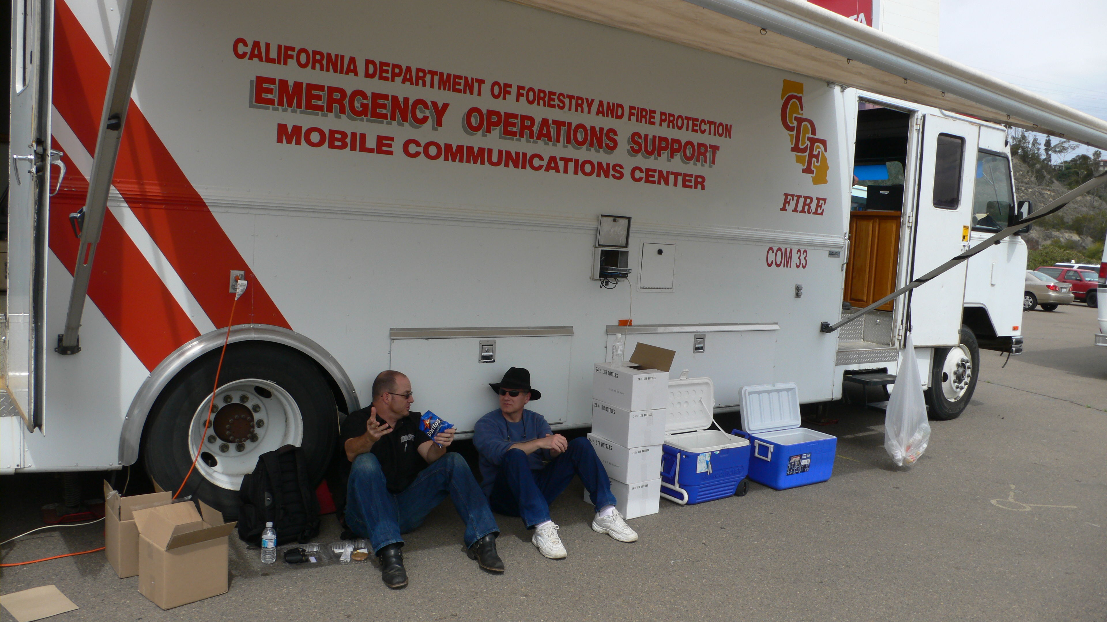
HPWREN team members taking a break during an exercise activity. |
|
HPWREN participated in multiple other Cal Fire or multi-agency exercises as well.
Adding to the available intel via sensor data
Implementing Real Time Sensors: to see or not to see what is going on
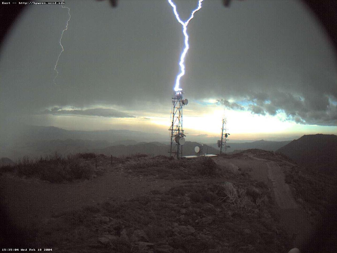
As a direct consequence of some initial weather-related wireless issues, HPWREN installed some meteorological sensors, not all of which worked out, and some were updated over time. Since those weather stations only gave an incomplete picture, such as they did not include information regarding cloud covers, HPWREN installed Axis pan/tilt/zoom cameras on five mountain tops as its first-generation equipment, starting in December 2000. This was originally the sole reason HPWREN had deployed weather stations and cameras, specifically for its own and internal reasons to assess impact factors for network performance. However, the HPWREN sensors with the project's public and unrestricted data availability became quickly very popular with firefighters and others, especially after HPWREN gave CDF access to the images and camera control early on, resulting in not much later ECC officers explaining that HPWREN cameras were the first thing they look at when a new fire call comes in. This has been a message heard many times since, indicating a real need. A 2004 article provides further insight on this.
|
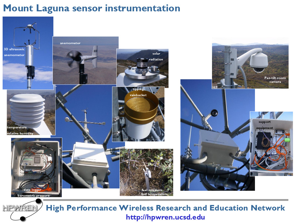
Installed in 2002, this slide shows HPWREN's original sensor suite on Monument Peak, including a solid-state 3D ultrasonic anemometer, a more conventional anemometer, temperature, relative humidity, solar radiation, fuel temperature and fuel moisture probes, as well as a tipping rainbucket and a Pan/Tilt/Zoom camera. |
|
However, starting in about 2003 HPWREN began to phase the PTZ sensors out in favor of a second generation of cameras, consisting of fixed quads of 90-degree imagers for persistent 360-degree views. A significant driver for this were statements by the then ECC Chief and an ECC Captain responding to a question by the HPWREN PI, while having a side-by-side comparison on two mountain tops, that the fixed cameras are preferable due to their clearer and higher resolution images, as well as their predictable view, undisturbed by someone else operating camera movements or zoom. The fixed cameras had no moving parts. Other factors for the replacement included the lack of reliability of the early 2000s Axis cameras with their fragile acrylic domes and arcing internal contacts in high winds. Soon 360-degree systems became the standard camera set of choice on HPWREN while finding more use among firefighter, other first responders, as well as the general public.
Over time, the preferred camera had six megapixels per chip, and both separate color and monochrome imagers, amounting to two imagers per camera enclosure times four cameras per site as 48 megapixels being collected at a baseline rate of once per minute. Currently deployed at about thirty sites in Southern California, this amounts to roughly 240 cameras and almost 350,000 collected and archived images per day, which are also converted into time-lapse videos every three hours. The benefit of the separate monochrome chip includes higher camera light and near-infrared sensitivities.
In 2013 a new and separate ALERTTahoe project started at the University of Nevada, Reno, with the installation of their initial camera sites based on newer Axis pan/tilt/zoom cameras around Lake Tahoe. Remarkable improvements to the Axis cameras in the decade since they were used in the HPWREN network included much higher environment resiliency and a 2 megapixel image resolution. Around the end of 2016 HPWREN partnered with ALERTTahoe to deploy their technology on Santa Ynez Peak in Santa Barbara County, alongside an HPWREN fixed 360 degree camera system and weather station. These cameras proved to be invaluable during the July 2017 Whittier Fire. By the end of 2017, HPWREN hosted 16 additional sites in San Diego County using such Axis pan/tilt/zoom cameras, with funding support through San Diego Gas and Electric. Starting in 2018 the Axis pan/tilt/zoom cameras supported by HPWREN were integrated into the newly formed ALERTWildfire project, with additional coverage in the Orange, Los Angeles, and Riverside counties, while continuing to operate independent of the system of HPWREN cameras and other sensors.
From a public safety perspective, based on 20 years of field experience, it has become clear that multiple types of sensors have value for providing real time situational awareness. It has also become clear that one size does not fit all. At mountain top sites with significant infrastructure and unobstructed views, we find that a combination of two PTZ cameras collocated with four fixed field of view cameras provide the most complete coverage. These sites can be augmented with meteorological, seismic, and/or GPS sensors as needed to fill in gaps of coverage. Other sites may only require a subset of these or other sensors. New kinds of sensors, such as air quality will provide for additional options in the future.
More than 1,000 IP addresses are accessing HPWREN sensor data during a typical day, and many times that can be seen during a significant fire or dangerous weather period. The US National Weather service is a significant user of HPWREN data, and uses it on their forecast pages, such as for Toro Peak and Mt. Woodson. Most HPWREN meteorological sensors collect and archive the real-time data once per minute, with wind data being stored at a once per second rate.
Transforming Data to Information: making raw data presentable
Images from the initial installation of cameras on HPWREN were accessible via the HWPREN web pages and archived. Images were taken from each camera every minute creating the opportunity for time-lapse animations. The first major use of post-processed time-lapse animations was a DVD documenting the progression of the 2003 Cedar Fire. In addition to the imagery from different viewpoints, an HPWREN camera stationed at the Air Attack Base proved that the story news channels spread about the firefighter airplanes not flying in the early morning after the Cedar Fire ignition was incorrect.
In 2013 HPWREN started to make fire videos publicly available on YouTube starting with the 2013 Chariot Fire, the 2007 Harris fire, and most major fires in the HPWREN coverage area since summer 2013. This archive also includes some HPWREN-related non-fire videos, such as flooding events of the Santa Margarita River, habitat regrowth after wild fires, and interesting encounters during field work.
In 2016 HPWREN started experimenting live streaming data on YouTube. Prototyping was done using a controlled burn observed from Mount Laguna Observatory, and a flooding event in the Santa Margarita Ecological Observatory. The value of this technology really took off during the 2017 Whittier Fire observed from Santa Ynez Peak in Santa Barbara County. Three separate feedback quotes from various fire agency officers about the HPWREN real-time streaming of camera images included:
|
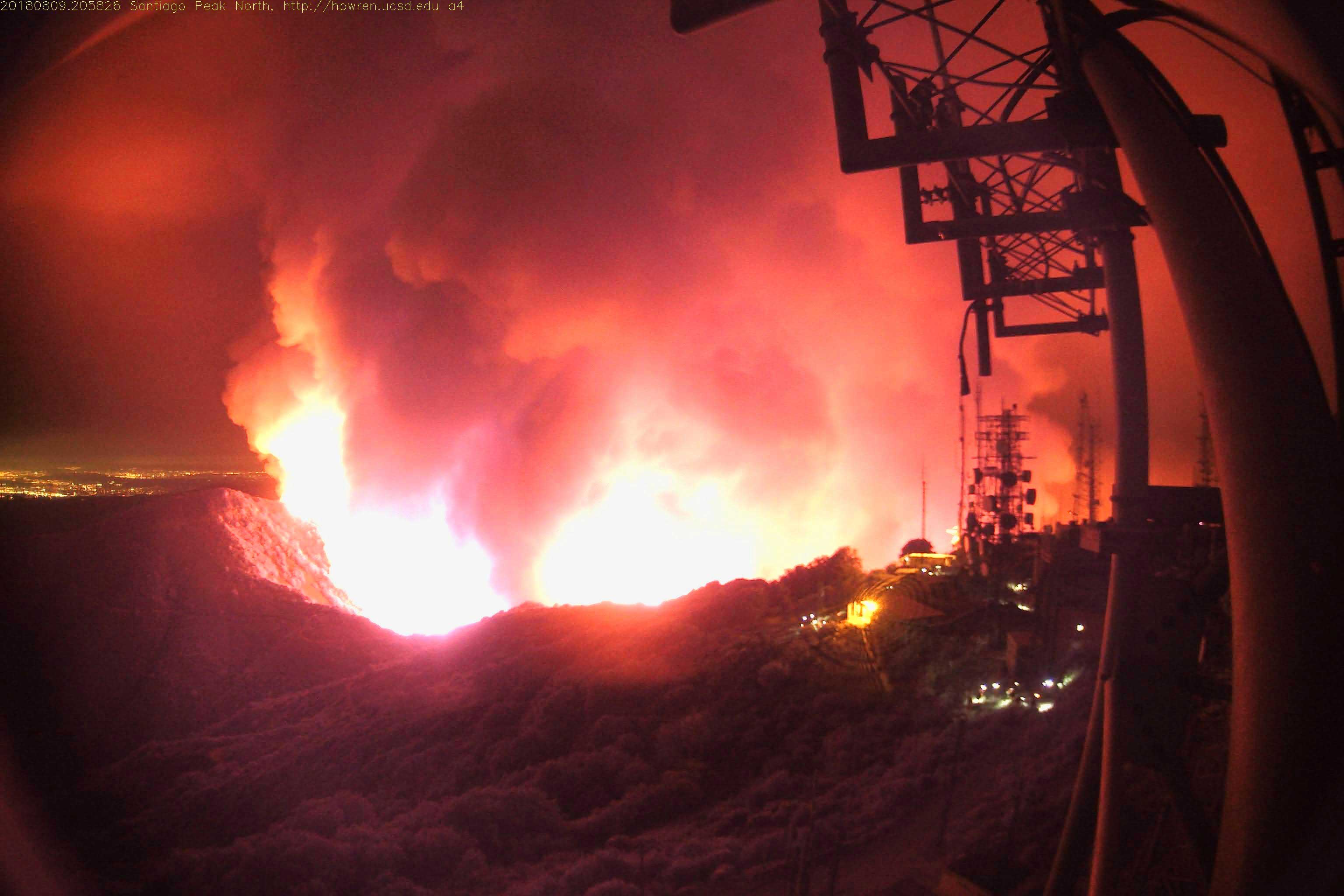
The 2018 Holy Jim Fire in Orange County almost reached the HPWREN node on top of Santiago Peak. |
|
YouTube live streaming for major fires is now a common occurrence on HPWREN, and, according to YouTube statistics, easily results in many thousands of views, such as for the 2017 Whittier, 2017 Lilac, 2018 Holy Jim, and the 2020 Bobcat Fires.
|
In 2017 the Whittier Fire near Santa Barbara eventually surrounded Santa Ynez Peak, which allowed for some uncomfortable videos, especially when watched as 360 degrees in Virtual Reality. This image shows some ways of combining the four 90+ degree fixed field-of-view camera images into such a 360 degree layout, with https://www.hpwren.ucsd.edu/news/20170815/ describing more details. |

|
Enabling Research
In 2003, a CDF captain at their Ramona Air Attack Base tested a non-networked HPWREN-provided monochrome camera on their OV-10. He then reported that he was able to see the fire through thick black smoke, due to the camera's high sensitivity in near-infrared.
When in October 2007 San Diego County was hit again by massive wildfires, HPWREN cameras provided valuable information to first responders, as well as to the public at large.
A collaboration with the National Park Service enabled HPWREN to collect large-size digital images from atmospheric visibility cameras at the Cabrillo National Monument. This was based on inexpensive consumer-grade cameras, which could be of value to ad-hoc deployments, for example in a wildland fire situation, possibly as expendable systems. Since HPWREN, in conjunction with Calit2, archives long term image data, it is possible to support post-fire research across multiple years, an example being the regrowth of vegetation.
The HPWREN project supported a collaboration in 2009 between Cal Fire and the MIT Lincoln Lab on Enhanced Situational Awareness for First Responders, which included mounting a pair of visible light and thermal IR cameras underneath the OV-10 Air Attack plane, while a receiver with a steerable tracking antenna on a mountain top connected this setup via the HPWREN network node on that mountain.
Multicast distribution of HPWREN sensor data set in motion an ability to easily analyze the resulting sensor output on multiple machines without an impact on the data collection or its archiving. This facilitated the creation of a system in 2004, which is still active today in 2021, in which a fully automated and continuously running process receives meteorological data, analyzes it in real-time for Santa Ana conditions, and, also in real-time, alerts the Cal Fire Emergency Command Center and others of such events via paging or email. The description was updated in 2018.
An effort was made to add more sensors at various sites, starting with cameras and meteorological stations, followed by prototypes of acoustics (followed up with additional activities in 2008) and water quality sensors. Work with hydrology sensors was extended in 2009.
For an ability to have sensors in real-time and at the right locations during emergencies, HPWREN demonstrated in 2007 an experimental platform for an ad-hoc long-distance wireless camera and weather sensor deployment.
|
An event-deployable sensor system shows its receiving antenna connected to a camera and a solid-state anemometer capable of collecting once per second wind data. Such fast data collection could be used to quickly warn firefighters of significant changes in wind speed or direction in the vicinity of a fire. |
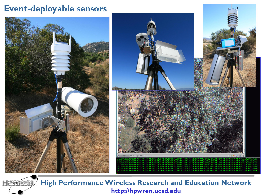
|
Another example of the camera data having been useful was during the Chariot Fire in 2013 where in result an HPWREN representative had to testify in court about how the images were being collected, as they were being used for evidence to show circumstances under which the fire started.
The sets of four fixed cameras covering all 360 degrees provided encouragement to display them in a pan-able video or with virtual reality glasses. An example visualization about what it looks like being on a mountain top engulfed by fire, created by a person outside of HPWREN, shows 360 degrees of seamless and non-overlapping images in a video of the 2017 Whittier Fire near Santa Barbara.
Examples of other real-time data generators on HPWREN that can be of use to first responders include seismic sensors, earthquake early warning and a network of fixed-location very high-precision GPS interfaces.
Unrestricted availability of HPWREN data sets, such as camera images, alongside more compelling visualization methods in part laid some ground work for follow up activities, such as SDFireSight in 2011 with the County of San Diego, a 2011 NSF EAGER award on a "Wildfire Modeling and Prevention Initiative: Developing a Technical Framework for Integrating Research with Public Policy Decision Support" and the NSF funded WIFIRE project in 2013.
Other notable activities
In July 2001 the HPWREN PI had been asked to provide testimony before the U.S. House of Representatives Subcommittee on Research about the NSF-funded HPWREN project. Throughout the history of HPWREN there have been many other presentations to federal, state, and local legislators and their staff.
|
In 2018 the HPWREN Project Director met with the San Diego County Board of Supervisors to address expanding the County's fire detection and response capabilities. |

|
HPWREN's annual users meetings often included first responder representatives, such as the 2003 event at the Palomar Observatory. The 2004 users meeting was hosted by the San Diego Sheriff's Department at the County's Emergency Operations Center. The meetings in 2005 (at the SDSU Santa Margarita Ecological Reserve), 2006 (in the hangar of Cal Fire's Ramona Air Attack Base), 2007 (at the Cabrillo National Monument, hosted by the National Park Service), 2008 (at the Pala Native American Reservation), 2009 (at the Palomar Observatory again), 2010 (at the San Diego Supercomputer Center), 2011 (at the U.S. Fish and Wildlife Service's San Diego Bay National Wildlife Refuge), and 2012 (at San Diego Gas and Electric's Mission Control site) were attended by first responders as well. None of those workshops were held between 2013 and 2018.
|
The 2006 HPWREN annual users meeting was held at Cal Fire's Ramona Air Attack Base, specifically in the AA330 hangar. This photo shows attendees in front of Tanker 70. |

|
In 2007 a CDF Fire Captain participated in an about interview the evolution of firefighting activities.
Also in 2007, results from a 2006 First Responder Survey of HPWREN Connectivity Deployment for Incident Command Posts were posted.
NSF suggested in 2008 that HPWREN compile a project summary video. The resulting video, also available on YouTube includes a first responder section.
With the HPWREN cyberinfrastructure by today being viewed by Cal Fire and other firefighting agencies as their operational Internet service provider to connect their distributed assets, regular meetings, usually every two weeks, between Cal Fire IT and HPWREN staff attempt to make sure plans and potential issues be openly discussed and addressed quickly.
HPWREN in 2021
Besides maintaining network stability, over the last several years the most important HPWREN objective has been to increase the network performance, both to support more sites as well as to substantially increase the speed and redundancy of the backbone network that holds the system together. Significant progress has been made in San Diego and Orange Counties, and a continuing build-out is planned to fill in gaps of coverage as defined by the fire agencies.
|
This image shows a screen shot of a Google Earth (KML) object, highlighting a somewhat recent HPWREN topology. It also includes fire station sites, as well as camera and weather sensors that are clickable to show real-time images and other data. |

|
HPWREN produces open data, while making such data available to various common operating pictures, emergency management and response agencies, researchers, environmental groups, and the general public.
A significant area of interest for the last few years has been to enable and facilitate activities that utilize HPWREN images for early fire detection. Projects such as AI For Mankind and Open Climate Tech have already shown substantial progress, often being able to identify a fire plume within its first few minutes of visibility. A summary about image processing experiments has resulted in the HPWREN Fire Ignition images Library for neural network training (FIgLib), which provides hundreds of image sequences of fire ignitions. In collaboration, an activity, provided by WIFIRE and SAGE, in conjunction with the Argonne National Laboratory, is going a step further by labeling the FIgLib data sets with both boxes and contours, so the data can be directly used for neural network training. The labeling itself is done by ANL, and a demonstration video about "How Fires Start: Fire ignition and early progression labels" is publicly available.
Acknowledgments
The HPWREN team would like to acknowledge the support and partnership over the years with the National Science Foundation, San Diego County Fire, San Diego County Sheriff's Department, San Diego Gas and Electric, Palomar Observatory, CAL FIRE, San Diego Supercomputer Center, California Institute for Telecommunications and Information Technology, and the many individual contributions that have made this work possible.
Background materials from HPWREN news updates
2000:
2001:
- Local CDF Firefighters Participate in HPWREN Mobile Rapid Response Demonstration
- HPWREN PI Testifies Before House Committee on Science
- Local agencies team with researchers for crisis management exercise
2002:
- SDSU Collaborates with HPWREN to Test High Performance Wireless Connection with Airplane
- Wireless Connectivity Enables Sensors on Coronado Bridge
- Researchers Continue to Examine HPWREN Connectivity Between Ground Station and Airplane
- San Diego County Sheriff's Department, UCSD, SDSU, and SSC-San Diego Researchers Collaborate for Real-Time Sensor Telemetry Instrumentation Atop Laguna Mountains
2003:
- San Diego Sheriff's Department Connects to HPWREN for Collaborative Evaluations of Emergency Data Communications Network Models
- San Diego's CDF Air Attack Base Collaborates with HPWREN for Mountain Sensor Access to Monitor Fire Conditions
- HPWREN Provides Data Connectivity for Remote Wildfire Operations Site
- Solid-State High-Res HPWREN-Connected Cameras Provide Quick Access to Environmental Conditions
- Second Annual HPWREN Users Meeting Focuses on Future of Network
- Time lapse animations and other images of the Cedar Fire incident
- CDF La Cima connection in the Cedar Fire post-burn area
2004:
- HPWREN Video Cameras Support Firefighting Agencies
- HPWREN Incident Response Connectivity Deployed to Support CDF Eagle Fire Operations in Riverside County
- Advances in Real-Time Sensor Data Distribution across HPWREN
- HPWREN's First Night Time Incident Response Deployment
- The Scripps Institution of Oceanography Visualization Center produced a DVD from HPWREN Cedar Fire images
- San Diego Sheriff's Department Hosts HPWREN Annual Users Meeting
- HPWREN sensor data used for setting off real-time alarms for firefighters
- New HPWREN Relay above Dos Picos County Park Supports CDF Incident Command Post Deployment and Wireless Network Experimentation
2005:
- San Diego County Real-Time Very High Rate High-Precision GPS Network Interfaces via HPWREN
- HPWREN Team Experiments with Real-Time Data from Automated Wildlife Acoustics Sensors
- A Short Case Study of HPWREN-Connected Anemometers in Hostile Weather Conditions
- Fire Exercise Allows HPWREN to Work with CDF and San Diego Sheriff's Department for Airdrop-Based Network Relay Installation Demonstration
- The San Diego County Sheriff's Department and the California Department of Forestry and Fire Protection airlift replacement sensors for HPWREN real-time weather alerts
- HPWREN establishes connection to CDF Helitack Base at Gillespie Field
- HPWREN Annual Users Workshop hosted at the SDSU Santa Margarita Ecological Reserve
- HPWREN's Fifth CDF Incident Response Deployment
2006:
- CDF Puerta La Cruz connects to HPWREN for Camp and ICP support
- Multi-agency collaboration prepares for Voice-over-IP phones at Firefighter Incident Command Posts
- HPWREN Provides Network Connectivity and VoIP to Horse Fire Incident Command Post
- HPWREN Team Participates in Ramona Air Show
- 2006 HPWREN Annual Users Workshop presentation slides
- Public Safety Agencies Begin Work on an HPWREN-like System for Southern California
2007:
- Smoke Signals: The Evolution of California Firefighting from the Eyes of Fire Captain Ron Serabia
- The 3Cs project and HPWREN demonstrated a multi-point video conference with a SDFD firefighter helicopter real-time video downlink during the 2007 Interagency Wildland Fire Drill
- Monkey flowers, river water, and soil health...
- 2006 First Responder Survey of HPWREN Connectivity Deployment for Incident Command Posts
- Experimental setup for ad-hoc long-distance wireless camera and weather sensor deployment
- The HPWREN backbone now extends via an FCC-licensed path from the ocean to the mountains
- HPWREN camera use during the October 2007 San Diego Fires
- 6th Annual HPWREN Users meeting held at the Cabrillo National Monument
2008:
- New large-size digital images available from visibility cameras at the Cabrillo National Monument
- HPWREN camera observes more than four years of post-fire plant regrowth
- HPWREN creates a project summary video for NSF
- HPWREN weather sensor updated on Lyons Peak
- Listen to the River and the Ocean: Experimental HPWREN Acoustics Sensors
- 7th Annual HPWREN Users meeting held at the Pala Native American Reservation
2009:
- Enhanced Situational Awareness for First Responders
- 8th Annual HPWREN Users Workshop held at the Palomar Observatory
2010:
- Cowboy Fire required HPWREN to deploy its seventh firefighter Incident Command Post connection
- Additional CAL FIRE station connected to HPWREN
- San Diego County and CAL FIRE Team with UC San Diego Researchers on Early Fire Detection System
- The 2010 9th Annual HPWREN Users Workshop was held at the San Diego Supercomputer Center
- Rainbow Conservation Camp and SDCFA Station 58 are now connected to HPWREN
- Palomar Mountain Volunteer Fire Department uses HPWREN for emergency communications during weather emergency
2011:
- Meeting Peak Public Demand for Emergency Data in Rural Areas
- Experimental real-time Google Earth visualizations of SDG&E and HPWREN meteorological sensor data focuses on Santa Ana conditions
- UC San Diego Receives NSF Support for Wildfire Modeling and Prevention
- The 2011 10th Annual HPWREN Users Workshop was held at the U.S. Fish and Wildlife Service's San Diego Bay National Wildlife Refuge
2012:
- New Web Camera Added to the HPWREN Network
- FIRE FIGHTING PREVENTION, INNOVATION & COLLABORATION
- The 2012 11th Annual HPWREN Users Workshop was held at the San Diego Gas and Electric's Mission Control site
2013:
- UC San Diego's HPWREN Aids Firefighters in Chariot Fire
- New High-Speed Backcountry Fire Station Broadband Network Unveiled
2017:
2018:
2019:
2020:
2021:
as well as YouTube references, including:
- Many time-lapse videos of fires
- 2003 Cedar Fire, narrated by CDF Fire Captain Ron Serabia
- Mt. Woodson airdrops during the 2007 Witch Creek Fire
- 2008 HPWREN overview video
- Looking back at more than 20 years of the High Performance Wireless Research and Education Network
- How Fires Start: Fire ignition and early progression labels
"Having been around this for so many years, I am always glad to see improvements (more sites, HD cameras) to the network. However, watching the live feed on the Whitter Fire last week gave all of us a chance to learn and put away something in our toolbox for later use.
"The live feed and High Def allowed us to watch the pre heating of the fuels from the fire at the bottom of canyon and then start the brush on fire farther up the hill. We were able to watch very important fire behavior without being in damage, record it and use it to app along to others. We got a up close look at how effective the helicopter water drops where, along with several air tanker drops over the two days. As I write this today, the fire last night picked up and came around the other side, we watched a hot shot crew on the hill protect it. If the IC or Operations were watching, they could see the crew was safe while working on top of the hill.
"To be able to add live streaming to a few of the mountain tops in San Diego would be a great addition to an already fantastic network."
"I can't explain how valuable the cameras are for not only the use of spotting a fire, but being able to see what the smoke looks like (color, direction).
"When we get a 911 call for a fire, we will automatically go to the cameras for visual confirmation of a fire. That helps us in determining the legitimacy of the call and by the conditions seen may have an effect on our response.
"Watching the live stream for the WHITTIER FIRE was beyond helpful because we could see the up to date conditions of the fire and what it was doing based on the fuels, topography, and weather. If we had that in San Diego County, I think it would be a tremendous help but also a tool that the ground resources can use for the same purposes."
"I felt it gave me the opportunity to view the current burning conditions and what could occur if we/I were to get a fire in similar terrain. This caused me to think about resource needs (Equipment, Aircraft, crews) if we were to get a fire as well as situational awareness for what the burning conditions are and are becoming very close to our home unit."