2018 HPWREN Accomplishments
January 31, 2019
2018 was a busy year for HPWREN. This article highlights significant activities undertaken in 2018 and some predictions for 2019 activities.
I. Awards and grants
-
CENIC Innovation award given to HPWREN, March 20, 2018
HPWREN and its partners WIFIRE and AlertTahoe jointly shared CENIC's 2018 Innovations Award under the rubric "Technology Projects to Combat California Wildfires". In recognition of work to bring advanced IT and telecommunications to the fight to contain California wildfires, the WIFIRE, HPWREN, and AlertTahoe projects were selected as joint recipients of the CENIC 2018 Innovations in Networking Award for Experimental Applications. More details are at https://cenic.org/news/item/2018awards_wifire.hpwren_alerttahoe.
-
San Diego County Supervisors voted to support HPWREN upgrade, Jan 24, 2018
The County of San Diego Board of Supervisors voted to approve an investment in system technology developed at the University of California San Diego that will improve the County's fire detection and response capabilities. The County's investment will result in the addition of new cameras and a boost in the network performance of hazard detection technology developed by the university.
The County unanimously approved $437,174 to undertake critical upgrades to the High-Performance Wireless Research and Education Network (HPWREN) and the ALERTWildfire network. HPWREN is operated by UC San Diego's Scripps Institution of Oceanography and the San Diego Supercomputer Center (SDSC) and ALERTWildfire is operated by the University of Nevada, Reno Seismological Lab. See /news/20180124/ for more information.
-
PRP contribution of 500TB distributed high availability storage system, Aug 2018
The Pacific Research Platform (PRP) contributed a 500 TB (Terabyte) storage system to HPWREN. This storage, along with cluster control system to access it, is distributed across 3 campuses (SDSC/UCSD, UCLA and UCSC). This new system will significantly improve storage performance and availability for HPWREN data, contributing to more persistent HPWREN services across multiple California regions.
II. Public Safety Services and Improvements
Santiago Peak - Deployed HPWREN Fixed and ALERTWildfire PTZ cameras, Aug, 2018
Santiago Peak, bordering Orange and Riverside Counties, was added as a new backbone and gateway site as HPWREN expands further north from San Diego County. HPWREN has installed 4 fixed cameras, 2 ALERTWildfire pan/tilt/zoom cameras, and a set of meteorological sensors just in time for supporting real-time monitoring of the Holy Fire starting Aug 6, 2018. Read more about the site and the fire monitoring at /news/20180812/
Mount Wilson Observatory - Deployed HPWREN Fixed and ALERTWildfire PTZ cameras, Oct 2018
Mount Wilson Solar Observatory is located in the San Gabriel mountains near Pasadena. The Peak has a wide unobstructed view of the LA Basin at over 1,700 meters elevation.
There are several observation projects operating at this site including the CHARA (Center for High Angular Resolution Astronomy) project with six telescopes run by Georgia State University. In collaboration with the CHARA project, 4 fixed and 2 pan/tilt/zoom cameras have been installed on a 150' Solar Tower owned by the Carnegie Institution of Washington, under the administration of the Mount Wilson Institute. The Mobotix cameras were provided by Orange County Fire Authority.
-
LA County Fire Department (LACoFD) Helibase 69 Bravo - Deployed HPWREN Fixed and ALERTWildfire PTZ cameras, Oct 2018
LA County Fire Department Helibase 69 Bravo sits high atop the Santa Monica mountain range with 2 mountain tops covering 34 acres 2400 feet above the Topanga and Malibu mountains. The site provides 360 degree, unobstructed views that stretch clear across the Santa Monica and Malibu hills and beyond. On clear days you can easily see from the Banning pass to the east to Ventura County toward the west and from the San Bernardino mountains south to Oceanside and beyond.
Rebuild of Big Black site
On January 28, 2018 a significant Santa Ana condition impacted San Diego County, and with it came substantial damage at about 10:08 AM to the Big Black Mountain relay site east of Ramona. The relay supports a link to the HPWREN backbone site on Mount Woodson, and connects a firefighting agency site. A set of 360 degree cameras, a PTZ camera, and a meteorological sensor set are also mounted to the solar-powered relay. 80-90 mile per hour winds were recorded in this area prior to the damage (/news/20180218/), which dislodged and bent a communication tower section, tore out its base mount, and destroyed numerous cable runs.
The site was completely rebuilt and restored to operations over the remainder of the year by the HPWREN team. Damaged materials were removed, assessed and the field site system design was reviewed and redesigned accordingly to help mitigate future weather events. Read all about it at /news/20190108/.
Improved HPWREN Camera Image Download Capabilities
HPWREN servers capture, process, publish and archive images and videos around the clock (images are captured once per minute, which are converted into videos every three hours). This data is collected from more than a hundred camera image sources around San Diego, Imperial, and Orange County and we continue to add new cameras. Our archives are spread across multiple servers and we provide multiple tools for their access. Images are stored as JPEG files and videos are stored as H.264 videos in MP4 container files. Our Archives date back to 2000 with the oldest images coalesced into MP4 videos to reduce storage requirements. Those MP4 videos can be downloaded and from them new JPEG files can be extracted, if desired.
HPWREN provides a number of mechanisms for our users to search for, view, and, if desired, download single or multiple images and videos (in custom packaged zip files when larger amounts of data are requested). Read all about them at /news/20180501/.
HPWREN Santa Ana Notifications Reinstated
An experimental update for real-time weather alerts, based on the original HPWREN implementation from 2004 (/news/041106.html), is now operating on a trial basis. This new version, which utilizes data from HPWREN and SDG&E weather stations, supports multiple profiles, including which sensor thresholds to use, which sensor subset to analyze (or "all"), and which email addresses to send the real-time alerts to. It currently analyzes data every few minutes from usually about 170 weather stations, with an ability to support many analysis profiles. You can read more about this at /news/20180415/.
Numerous interesting and informative youtube videos over 2018
See nearly 80 videos captured and created over 2018 (animations, split screens, surround views, etc.) of fires and interesting events captured by HPWREN cameras at https://www.youtube.com/user/hpwren/videos.
New news content on web site
Read more about HPWREN awards, accomplishments, cameras, fire monitoring and even Wolf puppies in 2018 news articles at /news/index-2018.html.
Boosted social media presence and increased twitter followers count by over 900%
Facebook: https://www.facebook.com/HPWREN.UCSD.EDU/
Twitter: https://twitter.com/hpwren
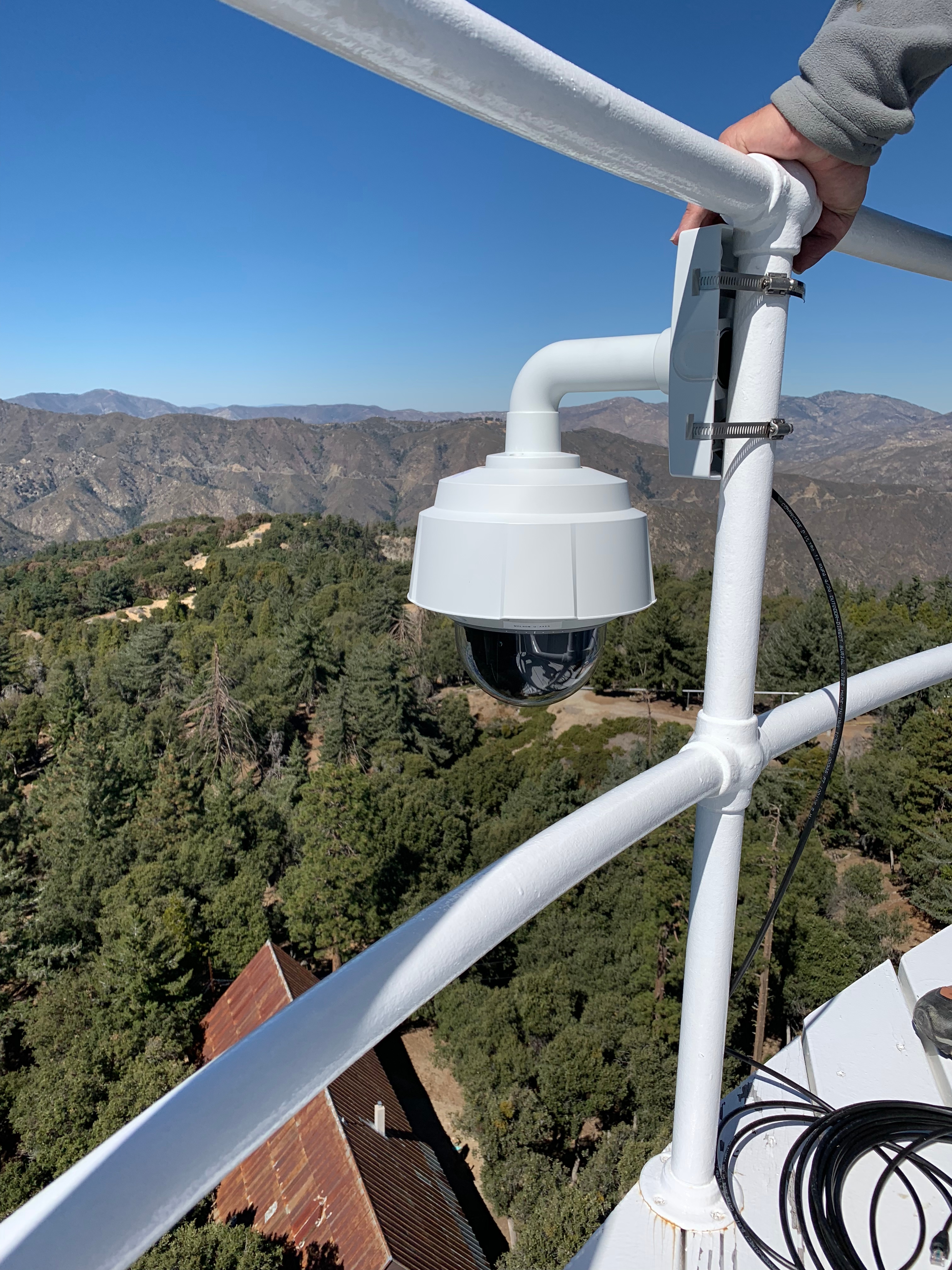
One of the PTZ cameras on Mount Wilson Observatory.
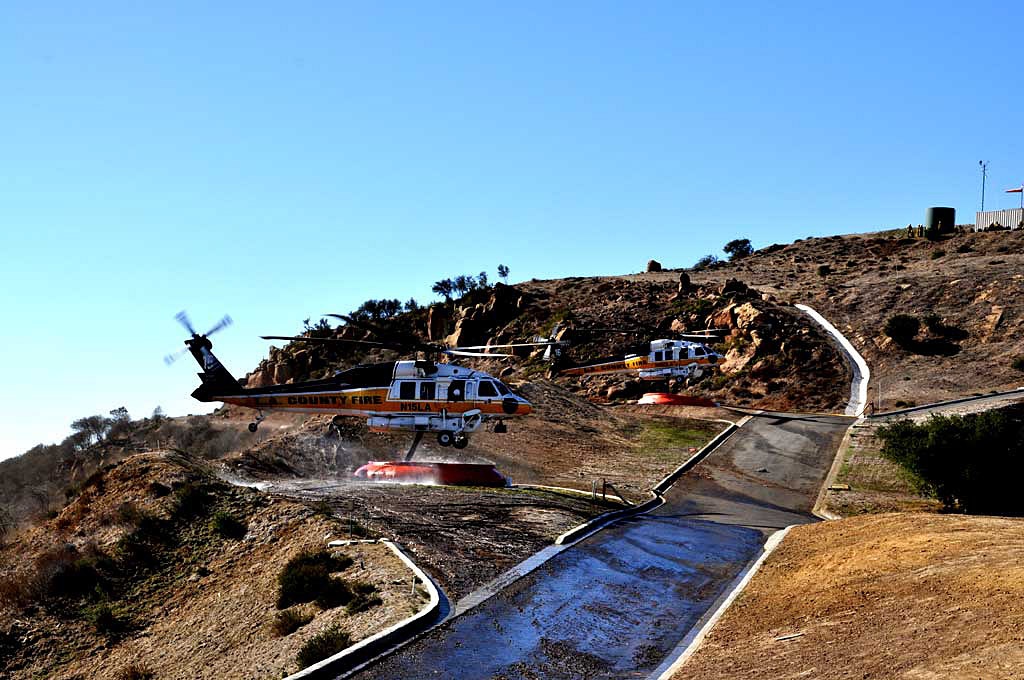
LA County Fire Department Helibase 69 Bravo.
III. IT infrastructure upgrades, services and support
Completed 4.9 Ghz licensing
We brought ASAPNet into compliance with FCC regulations for the use of the fixed 4.9 Ghz Public Safety band. A total of 69 ASAPNet fire stations, backbone sites, and relays were licensed. This improved our internal documentation and inventory for all sites where we have Public Safety equipment.
Improved networking
Network improvements have been made between HPWREN Fiona servers and the campuses at which they reside (UCSD/SDSC, SDSU and UCI). These include upgraded 10 GigE switching, dedicated fiber paths, more flexible routing protocols, and more resilient automated routing alternatives for access across HPWREN regional networks. This is in line with performance and reliability goals for supporting and maintaining public and first responder access to HPWREN data, even if one of our supported regions (across San Diego, Imperial, and Orange counties) suffers disaster.
Regional redundancy and resilience was added using UCI and SDSU locations to allow access to local servers as well as the HPWREN wireless network should UCSD and/or its servers become unavailable. The HPWREN network is now accessible from the public Internet via (BGP managed) redundant and resilient paths via separate network regional assignments (ASU’s) at UCI, UCSD and SDSU. Also, all current HPWREN Fiona servers are now connected via direct paths from central (SDSC resident) switching, for improved interoperability.
Re-engineering efforts to improve backbone link throughput and availability
Completed link studies to address the availability of spectrum and bandwidth either for new sites or to upgrade existing links. Most new links will adopt XPIC (cross polarization) configurations to maximize available throughput using dual channels. Funding is just now being released to us to start implementing these new link designs.
Improved throughput to the Zwicky Transient Facility at Mount Paloma Observatory (MPO)
Created aggregate 400+ mbit/sec connectivity to MPO by having two ~200+ mbit/sec paths, one via Monument Peak and one via Boucher Hill, upgrading mountain top equipment to 1 Gbit backplanes, and implementing MPLS on the HPWREN network. This not only provides additional throughput to MPO, but also helps balance the flow of network traffic, benefit many sites.
Next generation camera image fetching system developments
Prototype of next generation camera image fetch system has been tested for all current HPWREN camera types and against 1st generation CEPH storage system (in 2018). Going forward, system will be connected to the HPWREN HA (High Availability) distributed storage system mentioned above and further tested. Once prototype proof of concept and operational feasibility are confirmed, it will be containerized to support replication and scalability.
HPWREN 2018 ticket support system summary
454 Jira support tickets completed
430 Jira support tickets created
122 HPWREN service reports filed for field work. Broken down as:
HPWREN/ASAPNet - 52 service reports
ASAPNet - 68 service reports
AlertSDGE - 10 service reports
2019 Opportunities:
We are already in the midst of 2019 activities. Those activities include --
Moving the Boucher Hill site to a new tower
Moving Red Mountain cameras higher up to the top level of tower
Adding a Sky Oaks to High Point link
Upgrading multiple HPWREN backbone links
Adding 5 new camera clusters in San Diego County
Adding 5 new camera clusters in Orange County
Adding 4 new camera clusters in Santa Barbara County
Establishing Santiago Peak as an HPWREN radio gateway linking Orange, Riverside and San Diego counties
Implementation of a distributed high availability kubernetes cluster and storage system
Web camera set-up at San Diego State University's Sky Oaks Field Station.